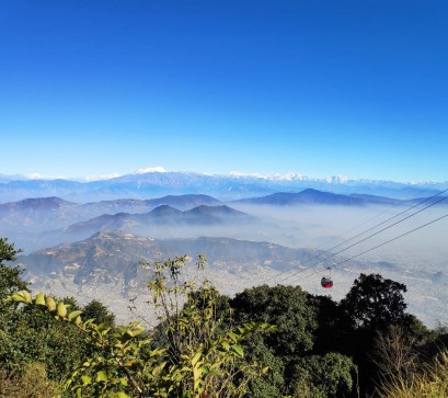
In the eastern region of Nepal, lies the unspoilt and comparatively unexplored Rolwaling trekking trail. The isolation of this area, the majestic mountain vistas, the variety of flora and fauna, and the rich local cultures can all be experienced on the Rolwaling trek. Rowaling is one of Nepal’s greatest high mountain valleys trek. The Rolwaling, a remote and isolated high valley, west of Khumbu region and straight on the Tibetan border, is known to the local Sherpas as “the grave”, due to its positioning between towering glaciers. The Rolwaling journey is a wonderful opportunity for trekkers, who don’t want to come across a large flood of visitors, but yet want to appreciate mother nature, magnificent Himalayan vistas, and discovering lovely waterfalls, Tsho Rolpa Lake, monasteries, and sceneries. Rolwaling trek takes you past scenic Sherpa, Tamang, and Chettri villages with their traditional terraced farms, through dense prehistoric forests, and over a huge bridge with stunning views as it passes through one of the most solitary and stunning regions of Nepal.

The Rolwaling trekking zone, which is located west of Everest and close to the border with Tibet, offers an exciting adventure that begins in Barabise, continues over Tinsang La Pass, and descends to Bigu Gomba, which is home to Buddhist nuns. The route turns into the Rolwaling valley, one of the most isolated, enigmatic, and interesting destinations in the Rolwaling trekking, as it descends the Bhotekoshi River. The region is rife with stories of the Yeti, the mysterious snowman fabled to be found in the Himalayas, and it is also where some mountaineers had formerly planned expeditions to hunt down Yetis.

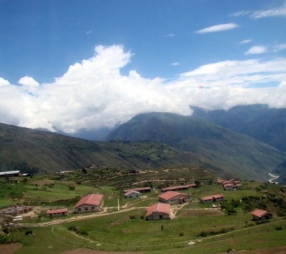
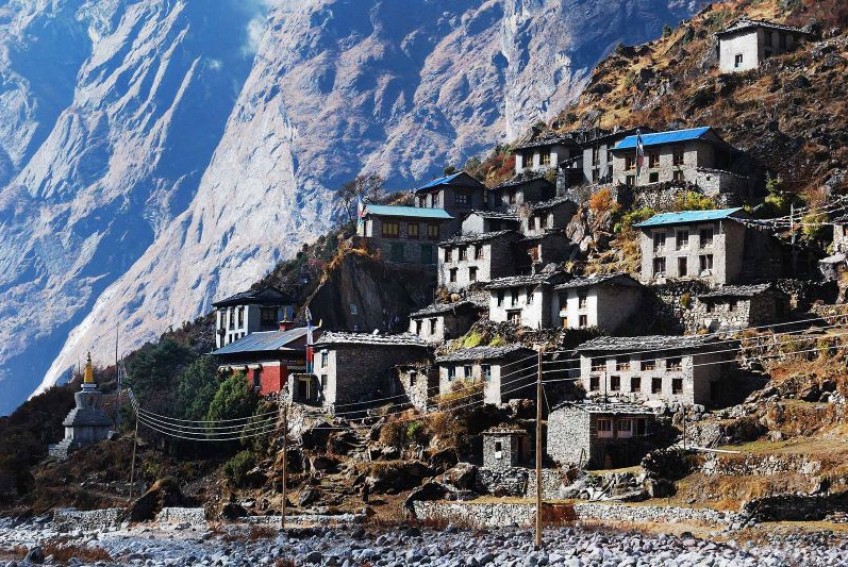
The trek’s highest point is Na Gaun, which is only a summer village, and Beding, the final settlement. The path ascends through a grassy valley to Tso Rolpa from the village of Na, then over a ridge on the north side of the valley to reach the head of the Tram Bau Glacier, whose water feeds the Rolwaling river.

There are many crevasses while trekking up Pachermo Peak (6273m) via the Rolwaling route. There is a Sherpa settlement named Biku, which means “seed” in their language. The primary attractions of a Rolwaling trekking are the views of Gaurishankar (7145m), Melungtse (7181m), and other mountains, as well as the villages of Beding (3690m) and Na (4183m) with its monastery, and Tsho Rolpa Lake. Following the route, the track descends to Thame from whence it continues down the BhoteKoshi River to Namche Bazaar and then on to Lukla for a flight to Kathmandu. If you have time, though, you may also go to Everest Base Camp.
An itinerary for the Rolwaling trek is shown below:
|
Day |
Activities |
|
Day 1 |
Arrive at Kathmandu |
|
Day 2 |
Drive Kathmandu to Sigatte (3345ft), 5-6 hrs |
|
Day 3 |
Sigatte to Jagat (4100 ft), 5-6 Hrs |
|
Day 4 |
Jagat to Simogaon (6643ft), 5-6 hrs |
|
Day 5 |
Simigaon to Donga (9185ft), 5-6 hrs |
|
Day 6 |
Donga to Beding (12105ft), 5-6 hrs |
|
Day 7 |
Rest at Beding and acclimatisation day: Malung Kharka hike, 5-6 hrs |
|
Day 8 |
Beding to Na Gaon (13750ft), 5-6 hrs |
|
Day 9 |
Rest at Na Gaon and acclimatisation day – Yalung La Hike 4-5 hrs |
|
Day 10 |
Na to Nyiduk Kongma (15582), 5-6 hrs |
|
Day 11 |
Nyiduk Kongma to Drolumba Glacier (17075), 5-6 hrs |
|
Day 12 |
Drolumbau Glacier to Tashi Laptsa Pass and decent to Camp, 6-7 hrs |
|
Day 13 |
Camp to Thame (12482), 5-6 hrs |
|
Day 14 |
Thame to Khumjung (12700 ft), 3-4 hrs |
|
Day 15 |
Khumjung to Monjo (9318ft), 3-4 hrs |
|
Day 16 |
Monjo to Lukla (9317ft), 4-5 hrs |
|
Day 17 |
Lukla to Kathmandu (8405ft), 35 mins flight |

You will pass through a gorgeous section of the Rolwaling trek path, where you will see beautiful glaciers, steep mountains, and snow-fed lakes. You will get the chance to interact personally with the local Tamang and Sherpa populations.
It is the ideal destination for a trek that involves some calm, introspection, and exploration.
Compiled By: Rebika Bishokarma
Photos By: Caingram, Base Camp Trekking, 7 Sumitters Brothers Trekking and Expedition
Also Read: